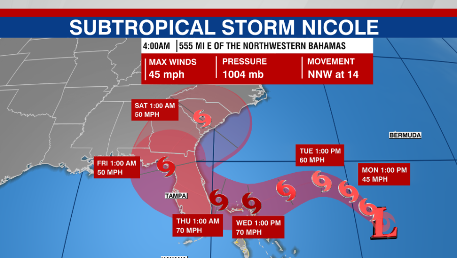
TAMPA, Fla. (WFLA) — A new named storm formed northeast of the Bahamas Monday, and is expected to bring heavy rain and strong winds to Florida later this week.
At 5 a.m. ET Monday, Subtropical Storm Nicole was located about 555 miles east of the northwestern Bahamas, and was moving north-northwest at 14 mph. It had maximum sustained winds of 45 mph, according to the National Hurricane Center.
The center said Nicole “could be near or at hurricane intensity by Wednesday or Wednesday night while it is moving near the northwestern Bahamas,” and that a “prolonged period of hazardous weather was expected over the northwestern Bahamas, Florida, and the southeastern coast of the United States this week.”
Nicole will likely near the northwestern Bahamas on Tuesday, move near or over the islands on Wednesday, before it approaches the east coast of Florida Wednesday night.
The storm is expected to dump 2 to 4 inches of rain on parts of the northwestern Bahamas Tuesday through Thursday, with some areas seeing isolated amounts of 6 inches.
Florida will likely see heavy rainfall from the system later this week.
A tropical storm watch was issued for the northwestern Bahamas, including Andros Island, New Providence, Eleuthera, Abacos Islands, Berry Islands, Grand Bahama Island and and Bimini.
Watches for Florida could be issued as soon as Monday, the center said.
Other areas to watch
Forecasters are watching another system about 650 miles east of Bermuda. The center gave it a 60% chance of developing into a tropical depression or storm sometime in the next 48 hours.
The center said a short-lived tropical storm could form Monday or Tuesday, but upper-level winds were expected to remain unfavorable for development, and it will dissipate and merge with a cold front.
The next named storm of the 2022 hurricane season would be Owen.


